
Seacrest County is a fictional setting where Need for Speed: Hot Pursuit (2010) takes place.
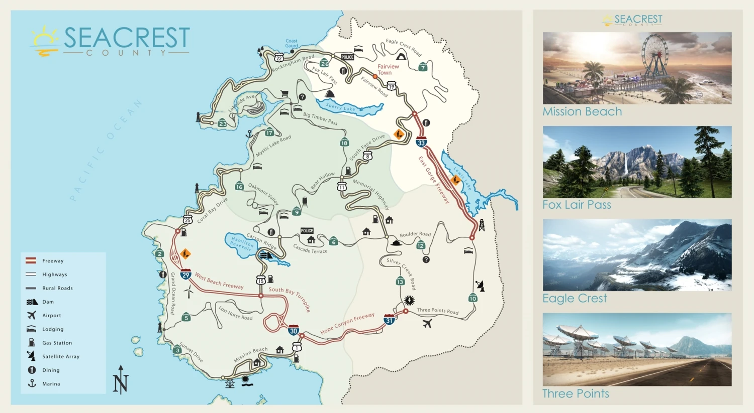
The rural Seacrest County is located along the West Coast of the United States with environmental attributes similar to that of Washington, Oregon and California. It is devoid of urban areas although scenic views and wide open roads await those who take their rides for a spin.
The SCPD , who are the primary law enforcement of the region, are the best of the best prepared to serve justice regardless of the risks.
Regions
Mission Beach
The south section of Seacrest County consists of a beachfront highway that stretches through the area and into the eastern mountains. The setting includes palm trees, beach houses, shops and a waterfront fairground. The Beach area includes areas such as Mission Beach and Grand Ocean Road.
Three Points
The desert makes up the east area of Seacrest County. Barren deserts like the East Gorge Canyon and Three Point Road are scattered with desert foliage, mesas and rocks. An airfield, a fort ruins and a national park are among the attractions in this vast desert region.
Eagle Crest
The mountains are probably the largest region as it takes up most of the north and northeast Seacrest County. It consists of stunning sights such as the ice capped mountains, valleys and caves. The dangerously windy mountain roads pass through areas such as Eagle Crest and Fairview Road.
Fox Lair Pass
The forest can be found in the centre of Seacrest County. Campsites and attractions line the roadside of the forest as well as locations like Fox Lair Pass and Big Timber Forest. Hairpins and sharp bends test a driver's drifting skills as well as shortcuts that help - or hinder - police pursuits.
Grand Ocean Coast
The Western region of Seacrest County consists of areas like Rockingham Point and Mystic Lake. Treacherous cliffside roads lined with helipads, country houses and tunnels run through this region. The Maplemount Country Houses are located off Lakeside Avenue.
Roads
There are a total of 26 roads in the Seacrest County:
South
West
Central
East
North
- South Face Drive
- Big Timber Pass
- Mystic Lake Road
- Fairview Road
- Fox Lair Pass
- Lakeside Avenue
- Eagle Crest Road
- Rockingham Road
Locations
- Mission Beach
- Grand Ocean Coast
- Coral Bay
- Boulder Desert
- East Gorge Canyon
- Fox Lair Pass
- Oakmont Valley
- Rockingham Point
- Eagle Crest
- Carson Ridge Reservoir
- Big Timber Forest
- Memorial Valley
SCPD
The Seacrest County Police Department is the agency that serves and protects Seacrest County from crime, including illegal street racing. They enforce the roads in over 55 types of vehicles from their fleet to combat the fastest and most daring of all speeders. The SCPD use roadblocks, spike strips, helicopters and EMPs to immediately put even the most dangerous of racers out of action.
Trivia
- Some easter eggs refer to Criterion Games' Burnout Paradise;
- The Maplemount Country Houses refers to the Maplemount Country Club.
- The South Bay Turnpike also refers to the South Bay Expressway as both are major freeway roads.
- One of the tunnels along the Westbeach Freeway is called the Harber Tunnel. There is a major road named Harber Street in Burnout Paradise which is entitled after the Lead Artist - Scott Harber.
- A carnival ride on the Mission Beach Fairgrounds features carriages resembling the Toy Hunter Cavalry and Toy Hunter Citizen which are both featured as part of Burnout Paradise's Toy Cars DLC pack.
- Buses in some parking bays can be seen with a "Carson" manufacturer logo which is a fictional American manufacturer featured in Burnout Paradise. The Carson Ridge Reservoir shares a similarly designed logo with Paradise City's electric company.
- The Hope Canyon Freeway resembles the I-70 highway route through the Glenwood Canyon.
- Coral Bay Drive resembles the Sea Cliff Bridge south of Sydney, Australia.
- Billboards advertising T-Mobile phone company are featured across Seacrest County.
| Need for Speed - Locations | |
|---|---|
| Locations | Bayview · Coast City · Fairhaven City · Fortune Valley · Lakeshore · Motor City · Olympic City · Palm City · Palmont City · Redview County · Rockport · Seacrest County · Tri-Cities · Tri-City Bay · Ventura Bay |